260
260
tv
eye 260
favorite 0
quote 1
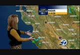
let's take about what waits for you. 37 santa rosa, 40 napa, a lot of 40s around our neighborhoods until you get to mountain view and san jose, 50 in mountain view and 51 san jose. the bay starting off with sunshine, mid to upper 40s. by noon mid to upper 50s. you can see mild this afternoon, close to average upper 50s to low 60s, heavier coat by 7:00, temperatures in the upper 40s to mid 50s for your evening nest fifths. -- evening festivities. upper 50s at the coast, fog stubborn inland visibilities down quarter mile or less in some areas that is going to hold temperatures back, afternoon sun upper 50s to low 60s. >>> so far friday light smooth sailing northbound 87 san jose traffic at the limit no problems past hp pavilion northbound. bunching up a little where 580 merges with 80, slow traffic in the westbound direction, a lot of headlights towards the macarthur maze and berkeley curve into the bay bridge toll, expecting m l any time it is moving, not -- expecting metering lights a time but it is moving. a look at our traffic app n is the waze app, mike has been talking about fog, our
let's take about what waits for you. 37 santa rosa, 40 napa, a lot of 40s around our neighborhoods until you get to mountain view and san jose, 50 in mountain view and 51 san jose. the bay starting off with sunshine, mid to upper 40s. by noon mid to upper 50s. you can see mild this afternoon, close to average upper 50s to low 60s, heavier coat by 7:00, temperatures in the upper 40s to mid 50s for your evening nest fifths. -- evening festivities. upper 50s at the coast, fog stubborn inland...
141
141
Dec 10, 2012
12/12
by
KGO
tv
eye 141
favorite 0
quote 0
fairfield six mile visibility, santa rosa 1 and 3/4 everybody else unlimited. land breeze keeping clouds out over the coast. coolest inland where we have the 40s, except napa 51 around the bay and coast in the 50s. 7:00 temperatures mid 50s inland i should say mid 40s inland mid 50s bay and coast sunny near 60 lunchtime, great time to be outside warm air mass will jump up to 60° by 4:00 low to mid 50s by 7:00. cooling tomorrow as sea breeze kicks in, tuesday night into wednesday morning, chance of steady rain once we get on the back side of the system pulling cold air almost from the north pole, mid 50s. >>> live shot of san jose highway 87 past hp pavilion julian exit a few headlights northbound, light, nice morning to be driving northbound on 87, westbound 80 east shore freeway past golden gate fields, university avenue into emeryville and into the macarthur maze light now you can see no problems once you get into the bay bridge toll, new reports of a stall past the metering lights on the right on the incline section. power lines down fairmont between 580 an
fairfield six mile visibility, santa rosa 1 and 3/4 everybody else unlimited. land breeze keeping clouds out over the coast. coolest inland where we have the 40s, except napa 51 around the bay and coast in the 50s. 7:00 temperatures mid 50s inland i should say mid 40s inland mid 50s bay and coast sunny near 60 lunchtime, great time to be outside warm air mass will jump up to 60° by 4:00 low to mid 50s by 7:00. cooling tomorrow as sea breeze kicks in, tuesday night into wednesday morning,...
176
176
tv
eye 176
favorite 0
quote 0
with the clouds starting to thin more fog could develop in the north bay, 39 in santa rosa and napa, everybody else in the low to upper 40s to even 50 now in san francisco. as we head throughout the morning it is going to feel much cooler than yesterday. 12° cooler to 20, 12 san francisco, 20 redwood city, 23 napa, need a heavier coat not one that is waterproof. temperatures in the 40s through 7:00, 50s by noon, near 60 at 4:00, you will need that jacket at 7:00 we are back into the low to mid 50s wet weather tomorrow, wednesday and then finally dry starting thursday. >>> east shore freeway headed past golden gate fields, 580 merges you can see getting busy, a little crowded because of cars coming together other than that things pick up nicely as you make your way in towards the macarthur maze. you are getting crowds as it gets busier bay bridge toll no metering lights yet cash folks paying a little bit of a price because they have a delay to the west grand overcrossing, carpool and fastrak moving nicely accident north 101 san francisco partially blocking right lane past candlestick
with the clouds starting to thin more fog could develop in the north bay, 39 in santa rosa and napa, everybody else in the low to upper 40s to even 50 now in san francisco. as we head throughout the morning it is going to feel much cooler than yesterday. 12° cooler to 20, 12 san francisco, 20 redwood city, 23 napa, need a heavier coat not one that is waterproof. temperatures in the 40s through 7:00, 50s by noon, near 60 at 4:00, you will need that jacket at 7:00 we are back into the low to mid...
158
158
tv
eye 158
favorite 0
quote 0
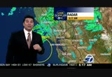
the morning commute only going to get harder to get around the next couple of hours, mid 50s santa rosa, low 60s fremont, mountain view, livermore and san francisco. mid 50s monterey bay and inland. rain this morning, showers this afternoon foggy the income couple of nights, brighter and drier the next couple of days, the next 10 to 14 days. here's the wave and front that is going to take the better part of the morning to move through. light to moderate rain through the lunch hour and then scattered showers for the afternoon and evening hours, maybe a lingering shower or two until 2, 3 in the morning by tomorrow's morning commute everything is starting to clear, fog will fade, partly sunny towards thursday afternoon clear during the evening hours which will lead to more fog. up to an inch around the bay and inch and a half north bay. by tomorrow a lot of sunshine, 50s for the game. temperatures below average dry friday through tuesday. be careful this morning. >>> live shot of east shore freeway 80 westbound, some sort of accident activity before university, big gap of traffic looks lik
the morning commute only going to get harder to get around the next couple of hours, mid 50s santa rosa, low 60s fremont, mountain view, livermore and san francisco. mid 50s monterey bay and inland. rain this morning, showers this afternoon foggy the income couple of nights, brighter and drier the next couple of days, the next 10 to 14 days. here's the wave and front that is going to take the better part of the morning to move through. light to moderate rain through the lunch hour and then...
386
386
tv
eye 386
favorite 0
quote 2
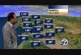
over the past six hours russian river only quarter of an inch, santa rosa half an inch. petaluma a little more than a quarter. let's talk about temperatures dress for mid 50s to low 60s. mid 50s around the monterey bay. rain this morning, showers this afternoon. foggy spots the next couple of nights brighter and drier starting tomorrow. here's that wave we talked about yesterday, hooking up with the front slowing progress bringing us the higher intensity of rain during the morning commute, you can see noon the steadier rain moves east, scattered light showers will continue during the afternoon hours if you have outdoor plans be prepared overnight maybe a stray shower then tomorrow's morning commute all gone a little fog forming then partly sunny and dry thursday afternoon. rainfall amounts up to half inch south bay, up to an inch around the bay and the east bay if you get caught under this training of these storms up to an inch and a half in the north bay. no worries for tailgating tomorrow the game ought to be in the 50s partly cloudy, temperatures slightly cooler, dry
over the past six hours russian river only quarter of an inch, santa rosa half an inch. petaluma a little more than a quarter. let's talk about temperatures dress for mid 50s to low 60s. mid 50s around the monterey bay. rain this morning, showers this afternoon. foggy spots the next couple of nights brighter and drier starting tomorrow. here's that wave we talked about yesterday, hooking up with the front slowing progress bringing us the higher intensity of rain during the morning commute, you...
286
286
Dec 10, 2012
12/12
by
KGO
tv
eye 286
favorite 0
quote 1
, record high in santa rosa, 80. sorry won't get close. >>> back to the bay bridge toll, sun is starting to come up you can see traffic backed beyond the west grand overcrossing towards the macarthur maze metering lights on, earlier stalls on the incline gone, the damage behind the toll is done. accident southbound 680 at vargas, off to the shoulder, on the sunol grade. another accident westbound 80 at cordelia truck scales, cleared, so towards the bay area. final look at our traffic app, this is our waze app showing san jose 280 at 87, accident blocking the left lanes, very heavy traffic northbound 280 as you make your way towards that junction, the gatt a parkway towards cupertino as well -- great app to navigate, tree on apple's app store and google play. handy to have, i have it and i use it all the time. >> that was a comprehensive look at traffic. thank you for joining us for the abc7 morning news. we continue in 25 minutes with news, weather and traffic during "good morning america." >>> i got a little tickle
, record high in santa rosa, 80. sorry won't get close. >>> back to the bay bridge toll, sun is starting to come up you can see traffic backed beyond the west grand overcrossing towards the macarthur maze metering lights on, earlier stalls on the incline gone, the damage behind the toll is done. accident southbound 680 at vargas, off to the shoulder, on the sunol grade. another accident westbound 80 at cordelia truck scales, cleared, so towards the bay area. final look at our traffic...
537
537
tv
eye 537
favorite 0
quote 0
the rain has ended for santa rosa. but still a line of heavy storms through the north bay and the south bay. napa through american canyon and vallejo still looking at heavy rain. an additional inch of rain is possible into the east bay. we have had flooding in contra costa county and heavy rain in the livermore valley and also around vasco road. lighter returns around 580 in dublin. you are under the small stream advisory until 12:15. that means you will see the runoff and more rain headed your way. you have seen rain rates of about a half inch per hour around this entire area whereas the north bay has been about an inch an hour as well as the south bay as well. so that's why we are looking at the santa cruz mountains. we have an additional two hours of rain headed your way. we are looking at the enhancement here and this is what you get closer to the higher elevations. the winds are still gusting from the south bay, the east bay and up to 49 miles an hour at the airport. take a look as that front pushes through, it is
the rain has ended for santa rosa. but still a line of heavy storms through the north bay and the south bay. napa through american canyon and vallejo still looking at heavy rain. an additional inch of rain is possible into the east bay. we have had flooding in contra costa county and heavy rain in the livermore valley and also around vasco road. lighter returns around 580 in dublin. you are under the small stream advisory until 12:15. that means you will see the runoff and more rain headed your...
296
296
tv
eye 296
favorite 0
quote 1
look at santa rosa. you know you are going to get problems when the wind are gusting over 40 miles an hour. we have branches down with our last couple of systems. the front is on the move. take a look at the east bay from concord, alamo, 580 and 880 and 680, meraga more heavy rain. back westward it's not as heavy but you have the gusty winds and it will pick up the next hour. union city, the dumbarton bridge, very wet weather and gusty winds down through the south bay. campbell and the santa cruz mountains, it will take until about 1:00. then we are looking at the rivers and streams rising here as well. here's a look at a loop. you will notice that even though the front begins to push slowly southward, we are still looking at the heavy rain really locked up into the north bay. within the next couple hours it continues to sink south. temperatures are mild in the 60s with the gusty south winds. we have the flood warning for napa and sonoma counties. that means flooding is happening right now. the flood wat
look at santa rosa. you know you are going to get problems when the wind are gusting over 40 miles an hour. we have branches down with our last couple of systems. the front is on the move. take a look at the east bay from concord, alamo, 580 and 880 and 680, meraga more heavy rain. back westward it's not as heavy but you have the gusty winds and it will pick up the next hour. union city, the dumbarton bridge, very wet weather and gusty winds down through the south bay. campbell and the santa...
113
113
tv
eye 113
favorite 0
quote 0
39 in napa, 40 in santa rosa, 44 san rafael, concord 41. mild around san jose and mountain view and san francisco 50 everybody he will in the mid to upper 40s. foggy inland through 7:00, the rest of us clear, brighter, slightly cooler noon mid to upper 50s. sunshine and high clouds by 4:00, low 60s. this evening 40s by 7:00. warmest days ahead of us tomorrow through monday when we could get near 70 most of us mid to upper 60s. great time to be outside. >>> san jose north 87 good ride at this early friday morning just a few headlights northbound past hp pavilion and julian on-ramp. san mateo bridge tail lights towards foster city and highrise traffic moving at the limit both directions on the san mateo bridge light. live shot of the bay bridge toll, a little busy, certainly no delays no issues on upper deck coming into san francisco. north 101 university on-ramp blocked with accident richmond eastbound 80 central off-ramp blocked while they clear an accident. >>> 4:40. >>> who says there is no such thing as a free ride? not san francisco mun
39 in napa, 40 in santa rosa, 44 san rafael, concord 41. mild around san jose and mountain view and san francisco 50 everybody he will in the mid to upper 40s. foggy inland through 7:00, the rest of us clear, brighter, slightly cooler noon mid to upper 50s. sunshine and high clouds by 4:00, low 60s. this evening 40s by 7:00. warmest days ahead of us tomorrow through monday when we could get near 70 most of us mid to upper 60s. great time to be outside. >>> san jose north 87 good ride...
189
189
tv
eye 189
favorite 0
quote 0
one inch in santa rosa. over an inch in san francisco. just under nine tenths in oakland. other locations received lower amounts of rainfall. concord about a third of an inch. where do we stand in terms of percent of normal rainfall? over 150% in most locations and nearly 200% of average in san francisco. we're not experiencing a rainfall deficit.tk; >> 40 trees toppled because of the recent storms, today about a dozen fell and have caused more damage. we're live tonight with the story. >> that is right. on 14th avenue in the richmond district. i'm using this light to sort of help knee navigate around here. this massive pile that you can see here is only a section of the huge eucalyptus tree that came down this morning. need less to say, crews were busy. trees and roofs combined with heavy winds can cause an old tree to topple in a storm this, one happened to also fall on a car. >> winds blow. as bad as today, we're busy. >> crews cut it down. it's the city's responsibility to trim the trees. >> we don't have the number of trues that we'd like. in fact tree maintenance cy
one inch in santa rosa. over an inch in san francisco. just under nine tenths in oakland. other locations received lower amounts of rainfall. concord about a third of an inch. where do we stand in terms of percent of normal rainfall? over 150% in most locations and nearly 200% of average in san francisco. we're not experiencing a rainfall deficit.tk; >> 40 trees toppled because of the recent storms, today about a dozen fell and have caused more damage. we're live tonight with the story....
155
155
tv
eye 155
favorite 0
quote 0
highway 1301, santa rosa. you can see the heavier rain in the darker green all throughout much of the north way and further south. novato, berkeley, a little heavier cell about to move into the east pay from concord to alamo. 580 and 80, the west weather. and back into san francisco, not only the wet weather, but we've had wind gusts up to 50 miles an hour. we have the flash flood watch, the wind advisory. not a lot going on right now in the south bay. but we are still looking at the rivers and streams from the santa cruz mountains up to the north. the napa river and up in gurnville as well because the rain will continue to sink to the south. wind advisory up until noontime, 51 miles an hour at the airport. we have wind, rain, the possibility of flooding and several hours of heavy rain coming our way. carolyn. >> thank you, lisa. you just talked about the wind so there are high surf advisories this morning. abc7 news reporter nick smith is in pacifica. let's try this again, nick. how is this going? >> carolyn,
highway 1301, santa rosa. you can see the heavier rain in the darker green all throughout much of the north way and further south. novato, berkeley, a little heavier cell about to move into the east pay from concord to alamo. 580 and 80, the west weather. and back into san francisco, not only the wet weather, but we've had wind gusts up to 50 miles an hour. we have the flash flood watch, the wind advisory. not a lot going on right now in the south bay. but we are still looking at the rivers and...
124
124
tv
eye 124
favorite 0
quote 1
temperatures 37 in santa rosa, 50 mountain view, 51 san jose. mid to upper 40s around monterey bay and inland. we are off to a cooler start today without the clouds of yesterday most neighborhoods it is going to be warmer today, within more possibility of fog being -- one more possibility of fog, warmest afternoons sunday, monday, tuesday. south bay low to mid 60s, 62 san jose, up the peninsula, 63 los altos, upper 50s coast today to near 60 downtown san francisco, over the golden gate 59 in san rafael, a lot of 50s north bay near 60 fog going to slow warming for you. upper 50s to low 60s the rest of the east bay valleys, low to mid 60s monterey bay and inland. tonight 30s inland and 40s, 40s stretch into the bay, 50 san francisco. the weekend temperatures are same tomorrow, mid to upper 60s sunday mid 60s to near 70 monday and tuesday, inside slider will bring more rain to the central valley and sierra wednesday and thursday and cools our temperatures into the 50s. >>> early trip into san francisco this friday morning you are in good luck live
temperatures 37 in santa rosa, 50 mountain view, 51 san jose. mid to upper 40s around monterey bay and inland. we are off to a cooler start today without the clouds of yesterday most neighborhoods it is going to be warmer today, within more possibility of fog being -- one more possibility of fog, warmest afternoons sunday, monday, tuesday. south bay low to mid 60s, 62 san jose, up the peninsula, 63 los altos, upper 50s coast today to near 60 downtown san francisco, over the golden gate 59 in...
151
151
tv
eye 151
favorite 0
quote 0
temperatures mild when you step out, mid 50s to low 60s 54 santa rosa, 62 in mountain view. mid to upper 50s 7:00 with everybody getting wet for the morning commute. noon the rain starts to change to showers very scattered during the afternoon hours upper 50s to low 60s showers will fade towards the evening. run of dry weather tomorrow, friday and saturday, temperatures a little below average at least dry and we'll see more sunshine. >>> get out on the roads it is wet, live shot of the bay bridge toll rain coming down, roads wet and slick, traffic fortunately, very light. earlier accident eastbound off of the bay bridge on the oakland side cleared. to the san mateo bridge, does not look like it is raining here now traffic very light past the toll plaza and the lights here and over towards the highrise no issues on the san mateo bridge nice drive between hayward and peninsula. westbound 580 before lake shore injury accident blocking right lane use extra caution reports of pooling water in the area. skyline boulevard south -- between highway 92 and 84 downed tree blocking both
temperatures mild when you step out, mid 50s to low 60s 54 santa rosa, 62 in mountain view. mid to upper 50s 7:00 with everybody getting wet for the morning commute. noon the rain starts to change to showers very scattered during the afternoon hours upper 50s to low 60s showers will fade towards the evening. run of dry weather tomorrow, friday and saturday, temperatures a little below average at least dry and we'll see more sunshine. >>> get out on the roads it is wet, live shot of the...
318
318
tv
eye 318
favorite 0
quote 0
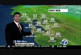
even at 38 santa rosa is a couple degrees warmer. san francisco 47. good morning redwood city, 48. 49 in mountain view and a mild, relatively speaking, 50 in san jose. that's five degrees above where you were yesterday but it's really fremont and livermore that are experiencing the much warmer conditions. not much change-up in san rafael, and subtle changes along the coast in san francisco. boy, a pretty mild to start out. just in the last hour numbers coming up along the shoreline. we will look for a little bit of fog here and there, but overall with the cloudy skies this morning that's keeping us a little warmer. then by the afternoon the winds will take over and that's going to usher in a slightly milder air mass. high pressure over the bay area continues to bring that sub continuance and that warming today and tomorrow. but by tuesday it will be coming to a screeching halt as we look for another wind shift. the temperatures will drop and then we will look for showers to head our way late tuesday into wednesday. so some of the forecasted highs toda
even at 38 santa rosa is a couple degrees warmer. san francisco 47. good morning redwood city, 48. 49 in mountain view and a mild, relatively speaking, 50 in san jose. that's five degrees above where you were yesterday but it's really fremont and livermore that are experiencing the much warmer conditions. not much change-up in san rafael, and subtle changes along the coast in san francisco. boy, a pretty mild to start out. just in the last hour numbers coming up along the shoreline. we will...
221
221
tv
eye 221
favorite 0
quote 0
santa rosa over two inches and close to four inches in a 24-hour period. san francisco an inch and a half and an inch and a half for oakland. check out concord. over two inches of course lesser amounts as you head south. san jose is close to an inch. you compare these numbers and add them on to the five-day storm total and check these out. close to 13 inches the last three storms. mount saint helena and san rafael, almost 7 and a half inches and close to five inches in napa. even san francisco and oakland close to four inches of rain. that's what we should see in the month and not just in five days. both locations quite a bit of rainfall and close to three inches in san jose. these past three storms gave us a lot, a lot of rainfall. we have another weak system that will move in here as we head into the midweek time frame. it is getting cool with 49 san rafael and 53 in san francisco. we have 47 in livermore. here is a look at what you can expect. a few clouds and cooler overnight. it will be a dry day tomorrow and then more rain moves in on tuesday night a
santa rosa over two inches and close to four inches in a 24-hour period. san francisco an inch and a half and an inch and a half for oakland. check out concord. over two inches of course lesser amounts as you head south. san jose is close to an inch. you compare these numbers and add them on to the five-day storm total and check these out. close to 13 inches the last three storms. mount saint helena and san rafael, almost 7 and a half inches and close to five inches in napa. even san francisco...
109
109
tv
eye 109
favorite 0
quote 0
santa rosa over two inches and close to four inches in a 24-hour period. san francisco an inch and a half and an inch and a half for oakland. check out concord. over two inches of course lesser amounts as you head south. san jose is close to an inch. you compare these numbers and add them on to the five-day storm total and check these out. close to 13 inches the last three storms. mount saint helena and san rafael, almost 7 and a half inches and close to five inches in napa. even san francisco and oakland close to four inchesain. that's what we should see in the month and not just in five days. both locations quite a bit of rainfall and close to three inches in san jose. these past three storms gave us a lot, a lot of rainfall. we have another weak system that will move in here as we head into the midweek time frame. it is getting cool with 49 san rafael and 53 in san francisco. we have 47 in livermore. here is a look at what you can expect. a few clouds and cooler overnight. it will be a dry day tomorrow and then more rain moves in on tuesday night and we
santa rosa over two inches and close to four inches in a 24-hour period. san francisco an inch and a half and an inch and a half for oakland. check out concord. over two inches of course lesser amounts as you head south. san jose is close to an inch. you compare these numbers and add them on to the five-day storm total and check these out. close to 13 inches the last three storms. mount saint helena and san rafael, almost 7 and a half inches and close to five inches in napa. even san francisco...
 Live Music Archive
 Librivox Free Audio
 Metropolitan Museum
 Cleveland Museum of Art
 Internet Arcade
 Console Living Room
 Books to Borrow
 Open Library
 TV News
 Understanding 9/11